Túneis em terras Nipónicas
Vou começar com este post uma série de post dedicados as grandes construções no Japão. Vou começar com túneis (uma vez que são o meus favoritos) , mais tarde pontes, barragens, e tudo mais que achar interessante.
No Japão merecem ser mencionados 5 túneis, porque para alem destes, o pessoal por cá farta-se de abrir buracos.
São eles: Hakkoda, Iwate-Ichinohe, Kanmon, Seikan, Tokyo Bay aqua Line, são considerados os mais importantes devido a sua extensão e características. De entre estes apenas tive oportunidade (ate ao presente momento) de passar em dois deles: Seikan e Iwate-Ichinohe.
Ambos os túneis são apenas ferroviários, o primeiro debaixo do mar, e o segundo a atravessar uma extensão brutal de montanhas.
Tunel Seikan:
Factos:
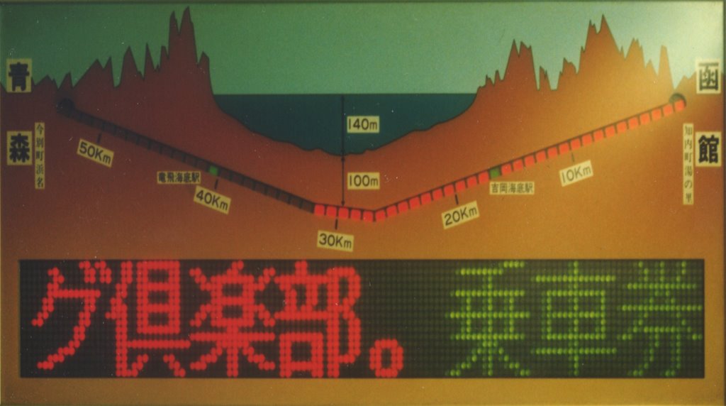
O Tunel Seikan ou 青函トンネル em Japonês é um túnel ferroviário com extensão de 53.85 km com 23.3 km debaixo do mar, sim porque túnel liga a ilha mais a norte(Hokkaido) com a ilha principal (Honshu) do Japão. Inpressionante não? É considerado o maior túnel ferroviário do mundo...

The name 青函 (Seikan) is a contraction of the principal cities on the line through the tunnel. The first kanji is from 青森 (Aomori) and the other from 函館 (Hakodate).
Na altura em começaram os trabalhos de construção do túnel os Japoneses, mesmo sendo eles os mestres a construir túneis tiveram alguns problemas especialmente de ordem geotécnica, o reconhecimento prévio deixava bastante a desejar face às reais condições encontradas por isso durante a construção que teve a duração de 17 anos, morreram 34 trabalhadores. E para quem gosta de saber quanto custou, este túnel está avaliado em 538.4 biliões de yen (US$3.6 biliões de dólares)
Faseamento dos trabalhos:
September 28, 1971
Main tunnel construction commenced
January 27, 1983
Pilot tunnel holed through
March 10, 1985
Main tunnel holed through
March 13, 1988
Tunnel opened
Para quem quer saber um pouco mais da geologia e condições geotécnicas aqui vai: Surveying, construction and geology
Surveying started in 1946. In 1971, 25 years later, construction began. In August 1982 less than 700 m remained to be excavated. First contact between the two sides was in 1983.
The Tsugaru Strait has eastern and western necks, both approximately 20 km across. Initial surveys undertaken in 1946 indicated that the eastern neck was up to 200 m deep with volcanic geology. The western neck had a maximum depth of 140 m and geology consisting mostly of sedimentary rocks of the Neogene period. The western neck was selected, with its conditions considered favourable for tunnelling.
Geology of the undersea portion of the tunnel consists of volcanic rock, pyroclastic rock, and sedimentary rock of the late Tertiary era. The area is folded into a nearly vertical anticline, which meant that the youngest rock is in the centre of the Strait, and encountered last. Divided roughly into thirds: the Honshu side consists of volcanic rocks (ansesite, basalt etc); the Hokkaido side consists of sedimentary rocks (Tertiary period tuff, mudstone, etc); and the centre portions consists of Kuromatsunai strata (Tertiary period sand-like mudstone). Igneous intrusions and faults caused crushing of the rock and complicated the tunnelling procedures.
Initial geological investigation occurred from 1946 to 1963, and involved drilling the sea-bed, sonic surveys, submarine boring, observations using a mini-submarine, seismic and magnetic surveys. However, to establish a greater understanding, horizontal pilot boring was undertaken - in both the service and pilot tunnels.
Tunnelling occurred simultaneously from both the northern and southern ends. The dry land portions were tackled with traditional mountain tunnelling techniques, with a single main tunnel However, for the 23.3 km undersea portion three bores were excavated with increasing diameters respectively: an initial pilot tunnel, a service tunnel and finally the main tunnel. The service tunnel was periodically connected to the main tunnel with a series of connecting shafts, at 600 - 1000 m intervals. The pilot tunnel served as the service tunnel for the 5 km centre portion.
Beneath the Tsugaru Strait use of a tunnel boring machine (TBM) was abandoned after less than 2 km due to the variable nature of the rock and difficulty in accessing the face for advanced grouting. Blasting with dynamite and mechanical picking were the excavation methods.
No Japão merecem ser mencionados 5 túneis, porque para alem destes, o pessoal por cá farta-se de abrir buracos.
São eles: Hakkoda, Iwate-Ichinohe, Kanmon, Seikan, Tokyo Bay aqua Line, são considerados os mais importantes devido a sua extensão e características. De entre estes apenas tive oportunidade (ate ao presente momento) de passar em dois deles: Seikan e Iwate-Ichinohe.
Ambos os túneis são apenas ferroviários, o primeiro debaixo do mar, e o segundo a atravessar uma extensão brutal de montanhas.
Tunel Seikan:
Factos:
O Tunel Seikan ou 青函トンネル em Japonês é um túnel ferroviário com extensão de 53.85 km com 23.3 km debaixo do mar, sim porque túnel liga a ilha mais a norte(Hokkaido) com a ilha principal (Honshu) do Japão. Inpressionante não? É considerado o maior túnel ferroviário do mundo...
The name 青函 (Seikan) is a contraction of the principal cities on the line through the tunnel. The first kanji is from 青森 (Aomori) and the other from 函館 (Hakodate).
Na altura em começaram os trabalhos de construção do túnel os Japoneses, mesmo sendo eles os mestres a construir túneis tiveram alguns problemas especialmente de ordem geotécnica, o reconhecimento prévio deixava bastante a desejar face às reais condições encontradas por isso durante a construção que teve a duração de 17 anos, morreram 34 trabalhadores. E para quem gosta de saber quanto custou, este túnel está avaliado em 538.4 biliões de yen (US$3.6 biliões de dólares)
Faseamento dos trabalhos:
September 28, 1971
Main tunnel construction commenced
January 27, 1983
Pilot tunnel holed through
March 10, 1985
Main tunnel holed through
March 13, 1988
Tunnel opened
Para quem quer saber um pouco mais da geologia e condições geotécnicas aqui vai: Surveying, construction and geology
Surveying started in 1946. In 1971, 25 years later, construction began. In August 1982 less than 700 m remained to be excavated. First contact between the two sides was in 1983.
The Tsugaru Strait has eastern and western necks, both approximately 20 km across. Initial surveys undertaken in 1946 indicated that the eastern neck was up to 200 m deep with volcanic geology. The western neck had a maximum depth of 140 m and geology consisting mostly of sedimentary rocks of the Neogene period. The western neck was selected, with its conditions considered favourable for tunnelling.
Geology of the undersea portion of the tunnel consists of volcanic rock, pyroclastic rock, and sedimentary rock of the late Tertiary era. The area is folded into a nearly vertical anticline, which meant that the youngest rock is in the centre of the Strait, and encountered last. Divided roughly into thirds: the Honshu side consists of volcanic rocks (ansesite, basalt etc); the Hokkaido side consists of sedimentary rocks (Tertiary period tuff, mudstone, etc); and the centre portions consists of Kuromatsunai strata (Tertiary period sand-like mudstone). Igneous intrusions and faults caused crushing of the rock and complicated the tunnelling procedures.
Initial geological investigation occurred from 1946 to 1963, and involved drilling the sea-bed, sonic surveys, submarine boring, observations using a mini-submarine, seismic and magnetic surveys. However, to establish a greater understanding, horizontal pilot boring was undertaken - in both the service and pilot tunnels.
Tunnelling occurred simultaneously from both the northern and southern ends. The dry land portions were tackled with traditional mountain tunnelling techniques, with a single main tunnel However, for the 23.3 km undersea portion three bores were excavated with increasing diameters respectively: an initial pilot tunnel, a service tunnel and finally the main tunnel. The service tunnel was periodically connected to the main tunnel with a series of connecting shafts, at 600 - 1000 m intervals. The pilot tunnel served as the service tunnel for the 5 km centre portion.
Beneath the Tsugaru Strait use of a tunnel boring machine (TBM) was abandoned after less than 2 km due to the variable nature of the rock and difficulty in accessing the face for advanced grouting. Blasting with dynamite and mechanical picking were the excavation methods.
posted by Ana Paula at 7:29 p.m.
![]()
0 Comments:
Enviar um comentário
<< Home